|
Climate
Throughout
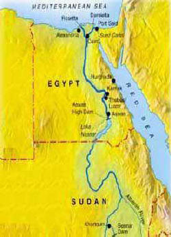
most of the year most of Egypt is hot and dry. Alexandria and the
Mediterranean coastal communities experience milder weather while the
heat in Cairo and other inland areas is fierce with temperatures rising
to as high as 50°C in some parts of the country.
Heavy winter rains fall along the
Mediterranean coast but are less frequent in Cairo and in the interior.
During the winter months (from November to February), however,
temperatures can fall to freezing. The spring in Egypt is generally mild
but plagued by the khamsin, a hot and bitter wind that brings blinding
sand and dust storms and heralds the coming of summer.
Natural resources
Egypt's most valuable mineral resource is oil, although the country also
has gold deposits as well as iron ore, manganese, phosphates and
uranium.
Flora
Although the
lotus and papyrus are symbols of Egypt, it is the date palm
that dominates the landscape. The Nile Delta and the Nile River Valley
have a rich variety of trees -- some indigenous, some imported --
including the tamarisk, acacia, eucalyptus, mimosa, jacaranda, cypress
and sycamore as well as a wide variety of fruit trees from citrus to fig
to mango.
Other fruits and vegetables flourish in the
fertile land along the Nile, as well as a vivid array
of flowers from the rose, Poinciana, lotus (of course), jasmine, lily
and bird of paradise. A multiplicity of grasses grows along the Nile as
well.
Fauna
Camels,
buffalo and donkeys are the most prevalent animals to be found in Egypt.
As for desert wildlife, the gazelle, jackal, jerboa and desert fox are
indigenous to the country, as well as
lizards and several venomous snakes.
Egypt is also
one of the greatest centers of Arabian horse breeding in the world with
large government-controlled stud farms under the auspices of the
Egyptian Agricultural Organization.
There are
about 200 species of migratory birds and 150 species of local
birds, including the marsh sandpiper, spoonbill, pink flamingo, hoopoe,
heron, stork, quail, egret and golden oriole. Eagles, falcons, vultures,
hawks and owls are among the birds of prey to be found.
Egypt also has a plethora of insect life,
including mosquitoes, flies, fleas and scorpions. There are said to be
as many as 190 species of fish in the Nile and many more in the
Mediterranean and Red Seas.
|
|